The National Parks & Monuments of the Great American West
When most people think of the Great American West, their minds naturally drift to the spectacular geysers of Yellowstone or the presidential faces carved into Mount Rushmore. Whilst these icons deserve their fame, there’s a remarkable collection of lesser-known treasures waiting to be discovered across the four states of Wyoming, Idaho, North Dakota and South Dakota.
Stretching from the northern plains to the Rocky Mountains, this is an area that is home to an extraordinary concentration of National Parks and National Monuments that together tell the story of America’s natural and human history. From ancient canyons to dramatic Badlands and pristine alpine lakes, the variety is simply stunning. The landscapes feel expansive, the wildlife abundant, and the sense of discovery genuinely thrilling.
Best of all, exploring this region feels like a proper adventure, with each state offering its own character. So, if you’re looking for an American road trip and want to experience some of the nation’s most spectacular scenery, join me as I explore the natural wonders of the Great American West.
“The Cowboy State” lives up to its Wild West reputation with wide-open spaces, rugged mountain ranges, and more pronghorn antelope than people. Wyoming offers some of America’s most iconic landscapes, from the geothermal wonders of Yellowstone National Park to the soaring Grand Tetons. Despite being the 10th largest state, it has the smallest population, perfect for those seeking unspoiled wilderness and a genuine taste of the frontier spirit.
Getting to Wyoming:
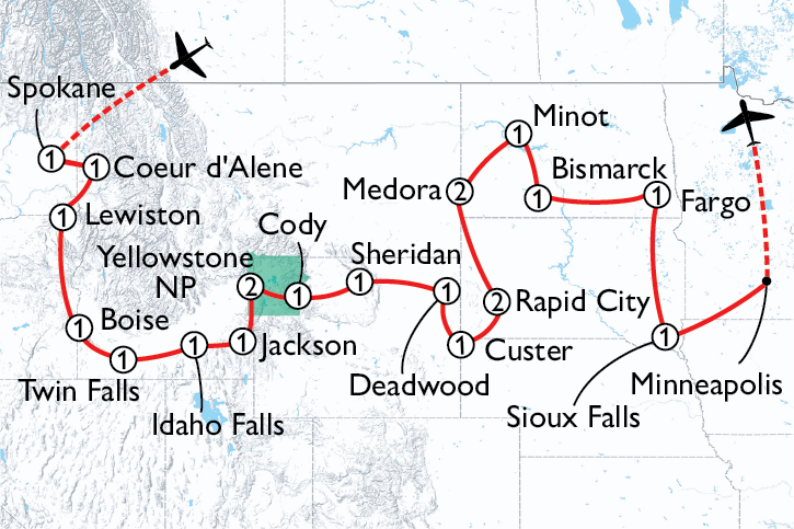
Most UK visitors fly direct into Denver International Airport (Colorado) or Salt Lake City International Airport (Utah), then begin a road trip towards Yellowstone
The alternative is to connect to a smaller regional airport like Jackson Hole, Cody, or Bozeman
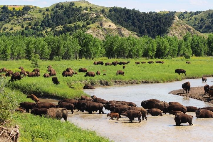
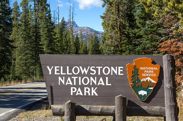
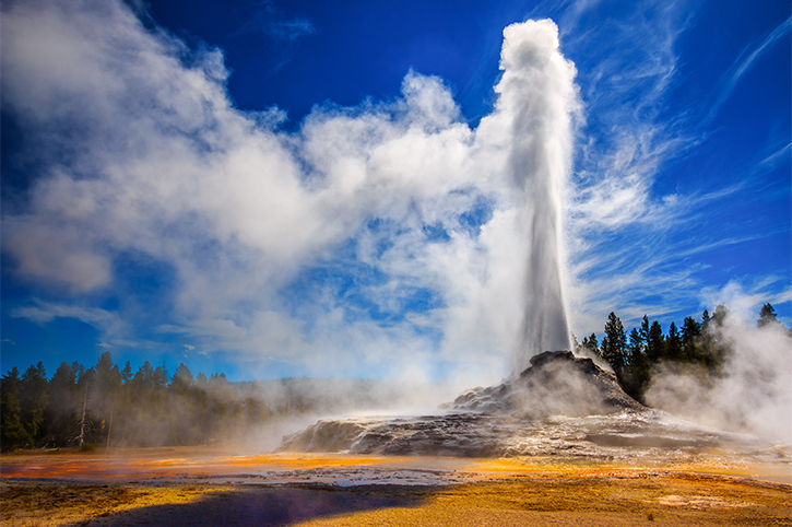
America’s crown jewel and the world’s first National Park, Yellowstone is a geothermal wonderland spanning over 2.2 million acres. The park showcases more than half of the world’s geysers, including the iconic ‘Old Faithful’, alongside the breathtaking Grand Canyon of the Yellowstone with its dramatic waterfalls.
I’ve visited Yellowstone twice now, and each time I’m struck by the sheer scale and variety of the landscape. One moment you’re watching bison grazing in Hayden Valley, the next you’re surrounded by hissing steam vents by the rainbow-coloured ‘Grand Prismatic Spring’ that looks like it belongs on another planet. The wildlife here is extraordinary: grizzly bears, wolves, elk, and herds of bison that can cause congestion, affectionately known as ‘bison jams.’ It’s one of the few places left in America where nature still rules the road.
Key Yellowstone Facts:
Yellowstone National Park was established in 1872
Yellowstone covers 2.2 million acres (roughly the same size as Cornwall and Devon combined)
Yellowstone’s signature features include: Old Faithful, Grand Prismatic Spring, Yellowstone Falls
Nearest airports to Yellowstone: Jackson Hole (JAC), about 60 miles to the South Entrance; Bozeman (BZN) about 80 miles to the North Entrance; Cody (COD) about 52 miles to the East Entrance
Nearest towns to Yellowstone: West Yellowstone, Jackson, Gardiner
Important! Yellowstone National Park has five entrances, but they are not all open year round. Check for road closures due to snow and plan your route carefully before you travel
Yellowstone Travel Tips:
By visiting in the shoulder seasons (May or September) you can avoid summer crowds. When I visited in early September, I had some of the major viewpoints almost to myself
Early morning starts are best for wildlife viewing. I got up at dawn to spot wolves in the Lamar Valley
Plan for at least three or four days to explore Yellowstone’s five distinct regions. However, you could easily spend a week here
Book your accommodations well in advance. Lodges and even RV parks fill up months ahead. The best locations sometimes sell out a year in advance for the summer season
Be ‘Bear-Aware’ and carry bear spray (available for hire locally) and store food properly. Rangers take this very seriously and so should you
Petrol stations in the park are limited and expensive, so fill up when you can outside the park
Yellowstone’s figure-of-eight road system can take up to five hours to drive without any stops, so don’t underestimate distances. It is best to drive only one loop each day
Grand Teton National Park
Rising abruptly from the Jackson Hole valley, the Teton Mountain Range creates one of America’s most dramatic landscapes. Unlike most mountain ranges that build gradually through foothills, the Tetons appear to just explode upwards from the valley floor, with peaks topping 13,000 feet.
Grand Teton National Park includes pristine alpine lakes, wildflower meadows, and world-class hiking with unobstructed views that photographers dream about. I’ll confess that I found the Tetons even more photogenic than Yellowstone, and I have some good photos on my wall of mountain reflections in perfect still lakes.
Key Grand Teton Facts:
Grand Teton National Park was established in 1929
The highest peak, Grand Teton, reaches 13,775 feet (4,199 metres) above sea-level
Grand Teton’s signature features include: Snake River, Jackson Lake, Cascade Canyon
Grand Teton wildlife: Moose, bison, black bears, pronghorn, bald eagles
Getting to Grand Teton National Park:
Nearest airport: Jackson Hole (JAC) – a 20-minute drive to the park entrance
Nearest town: Jackson, a charming Western town with excellent restaurants and boutique shopping
Grand Teton Travel Tips:
Combine Grand Teton with Yellowstone. They’re only 10 miles apart via the John D. Rockefeller Jr. Memorial Parkway, making for a perfect two-park itinerary
Jenny Lake is a ‘must-see’. In summer months there is a ‘shuttle boat’ to the trailhead for Cascade Canyon, saving a 2 mile walk
Autumn colours peak in late September, when the golden aspens beautifully contrast against the grey peaks
String Lake offers calm shallow waters perfect for kayaking and paddleboarding, so great for families
Winter transforms the park into a cross-country skiing paradise, though most non-ski facilities close
As well as Jackson, consider staying in nearby Teton Village or Wilson if you are on a budget
The Moose-Wilson Road is excellent for wildlife spotting, lookout for moose, unsurprisingly
Devils Tower National Monument
America’s very first National Monument, this 867-foot igneous intrusion rises dramatically from the Wyoming prairie like a natural skyscraper. The first time I saw Devils Tower was from about 20 miles away, and even at that distance it dominated the horizon. This massive, fluted column of rock seems utterly out of place in the surrounding grasslands.
Sacred to over 20 Native American tribes including the Lakota, Cheyenne, and Kiowa, the tower’s unique columnar formations also attract rock climbers from around the world, whilst its trail offers accessible views for all visitors. It’s also famous for its starring role in Steven Spielberg’s “Close Encounters of the Third Kind,” which seems entirely appropriate given how otherworldly it looks.
Devils Tower Key Facts:
Devils Tower was established as a National Monument in 1906
Devils Tower rises 867 feet into the air (264 metres) and is 5,112 feet above sea level
It is a volcanic formation of igneous rock
The tower and the area around it is of sacred significance for Northern Plains tribes
Famously, Devils Tower has featured in movies such as ‘Close Encounters of the Third Kind’ (1977) and ‘Paul’ (2011)
Getting to Devils Tower National Monument:
Nearest airports: Rapid City (RAP) 110 miles southeast; Gillette (GCC) 60 miles to the west
The 1.3-mile Tower Trail loops around the base of Devils Tower. Allow about an hour to walk it and bring binoculars to spot climbers on the tower face
June has a voluntary climbing closure out of respect for Native American ceremonies. The tribes hold sacred rituals here during this time
Try to visit at sunrise or sunset for dramatic lighting and photography. The tower glows orange and gold in the right light
Fossil Butte National Monument
Tucked away in southwestern Wyoming, Fossil Butte preserves one of the richest fossil deposits from the Eocene, roughly 50 million years ago. Back then, this arid landscape was covered by a vast lake teeming with fish, turtles, crocodiles, and even early mammals. Today, the sedimentary rock yields extraordinarily well-preserved fossils, including complete fish skeletons with scales and skin intact. The visitor centre houses an impressive collection, and if you time it right, you can watch palaeontologists preparing fossils in the laboratory. For anyone with even a passing interest in natural history, it is fascinating stuff.
Fossil Butte Key Facts:
Fossil Butte was established as a National Monument in 1972
The whole area of Fossil Butte covers 8,198 acres
The fossils found so far date from 50 million years ago
Notable fossils include fish, turtles, crocodiles, birds, bats and plants
Getting to Fossil Butte National Monument:
Nearest airport: Salt Lake City (SLC) 175 miles south
The visitor centre is excellent and should be your first stop. It is air-conditioned too, which was welcome on my summer visit
During the summer there are ranger-led fossil talks and hikes, so check the schedule when you arrive
The 2.5 mile Historic Quarry Trail climbs to an old fossil quarry site with panoramic views. It is moderately steep but rewarding, even on a hot day
You cannot collect fossils within the monument, but nearby private quarries do offer paid fossil-hunting experiences if you absolutely must take something home
Kemmerer has basic services and is the birthplace of JC Penney (there is a small museum if you’re interested)
I would recommend visiting from May through to September. The winter snows do close most roads and all facilities
Allow two to three hours minimum for a visit, but longer if you’re a geology enthusiast
You may also like…
Holidays to the Great American West Holidays by Freedom Destinations:
‘The Gem State’ is often overlooked by tourists rushing between Yellowstone and the Pacific Northwest, but that’s their loss. Idaho offers volcanic landscapes that look like the surface of the moon, world-class whitewater rafting, and a surprising collection of National Monuments that tell stories ranging from prehistoric horses to one of America’s darkest chapters during World War II. It’s a state of contrasts; rugged wilderness in the north, high desert in the south, and one that rewards the curious traveller.
Getting to Idaho:
Most visitors fly into Boise, Idaho’s capital, which has good connections from major US hubs
Salt Lake City and Spokane are alternative gateways. However, distances are significant, so plan accordingly
Craters of the Moon National Monument and Preserve
If ever a place deserved its name, it’s this one. Craters of the Moon is a vast volcanic landscape of lava flows, cinder cones, and lava tube caves that looks so alien that NASA astronauts trained here before the Apollo missions. I visited on a scorching August afternoon, and walking across the black lava fields felt like exploring another planet; a hot, hostile, utterly mesmerising planet.
The monument protects over 750,000 acres of volcanic features created by eruptions over the past 15,000 years, with the most recent activity occurring just 2,000 years ago. There are hiking trails ranging from easy strolls to more challenging climbs up cinder cones, plus several lava tube caves you can explore with a torch.
Craters of the Moon Key Facts:
Crates of the Moon was established as a National Monument in 1924. The preserve was added in 2000
The whole area, including the preserve covers an incredible 750,000 acres
Volcanic features include lava flows, cinder cones, lava tubes and tree moulds
Notable caves to explore are Indian Tunnel, Boy Scout Cave and Beauty Cave
Getting to the Craters of the Moon:
Nearest airport: Boise (BOI) 175 miles west; Idaho Falls (IDA) 85 miles east
Nearest towns: Arco (18 miles); Carey (24 miles)
Craters of the Moon Travel Tips:
Summer temperatures on the black lava can exceed 43°C (110°F) so I recommend visiting early morning or late afternoon, and carry plenty of water
The 7-mile loop road provides access to most of the major features. Allow a minimum of 3 hours just for this
Bring a good torch for exploring the lava tube caves; it gets very dark inside
Wear sturdy shoes. The lava rock is sharp and will shred casual footwear (and feet!)
Wildflowers bloom spectacularly in late May and June, softening the harsh landscape
The campground is basic, but atmospheric, if you want to experience the monument under the stars
Winter offers a completely different experience with snow-covered lava flows, but facilities will be limited
Arco is a quirky small town and worth a stop (it was the first city in the world powered by nuclear energy!)
Hagerman Fossil Beds National Monument
Along the banks of the Snake River in southern Idaho lies one of the most important fossil sites for understanding Ice Age North America. Hagerman Fossil Beds is best known for the Hagerman Horse, an extinct ancestor of the modern horse that roamed here over 3 million years ago. The monument has yielded specimens from more than 200 horse skeletons, along with fossils of sabretooth cats, mastodons, ground sloths, and over 200 other species.
Whilst much of the fossil-bearing area is closed to protect ongoing research, the visitor centre offers excellent displays, and scenic overlooks provide views across the Snake River valley where these ancient creatures once lived.
Hagerman Fossil Beds Key Facts:
The Hagerman Fossil Beds were made a National Monument in 1988
The fossil beds cover an area of 4351 acres
The fossils are from the Pliocene era (3.5 million years ago)
Notable fossils include the Hagerman Horse (the state fossil of Idaho!), mastodons and sabretooth cats
Getting to the Fossil Beds National Monument:
Nearest airport: Boise (BOI) 95 miles west; Twin Falls (TWF) 35 miles east
Nearest towns: Hagerman (adjacent); Twin Falls, (35 miles)
Hagerman Fossil Beds Travel Tips:
Start at the visitor centre in Hagerman village, for context and orientation. The staff are knowledgeable and enthusiastic
Most fossil sites are closed to public access to protect them, but overlook trails provide good views
The Oregon Trail passes nearby; interpretive signs connect the ancient past with pioneer history
Combine your visit with nearby Thousand Springs State Park, where massive springs gush from canyon walls
Spring and autumn are ideal visiting times as summer can be very hot
I would allow about two hours for your visit, unless you’re a palaeontology enthusiast, in which case allow longer
The small town of Hagerman has basic services and a friendly café
Minidoka National Historic Site
This is a different kind of monument altogether; one that preserves a painful chapter of American history. During World War II, over 13,000 Japanese Americans were forcibly relocated to Minidoka, one of ten internment camps scattered across the western United States. Families lost their homes, businesses, and freedom simply because of their ancestry.
The Minidoka National Historic Site preserves several original buildings, including a barracks, warehouse, and guard tower, and has interpretive exhibits that tell the personal stories of those who were imprisoned here. It’s a sobering, but important place, and a reminder that even democracies can lose their way in times of fear.
Minidoka Key Facts:
Established in 2001, Minidoka was formally designated a National Historic Site in 2008
The internment camps were in operation between 1942 and 1945
At its peak Minidoka housed 13,000 Japanese Americans
The remaining structures include the barracks, guard tower, cellar and fire station
Getting to Minidoka:
Nearest airport: Boise (BOI) 130 miles west; Twin Falls (TWF) 45 miles east
Nearest town: Jerome (16 miles) or Twin Falls (17 miles)
Minidoka Travel Tips:
The visitor centre is open seasonally and provides essential context before visiting
The historic site is 16 miles northeast of Jerome on rural roads, so follow the directions carefully
A self-guided walking tour connects the preserved buildings. Allow at least an hour to explore
The annual Minidoka Pilgrimage in June brings together former internees, descendants, and supporters. A moving experience if you can attend
This site may not be appropriate for very young children given the subject matter
Visit with respect and an open mind; this is a place for reflection and learning
Spring and autumn offer the best weather; summer is hot and winter can be harsh
The nearby town of Twin Falls has full visitor services and some spectacular waterfalls!
Travel inspiration, delivered straight to your inbox:
I am interested in…
.
Thanks! Please check your inbox for an email to confirm your subscription.
North Dakota
The ‘Peace Garden State’, named after the International Peace Garden on the Canadian border, is America’s least-visited state, which is both a shame but, selfishly, rather nice for those of us who do make the journey!
North Dakota’s landscapes are subtle rather than showy. Rolling prairies, mesmerising Badlands, and big skies that seem to go on forever. President Theodore Roosevelt fell in love with this land in the 1880s, and it’s easy to see why. There’s a real sense of space and solitude here.
Getting to North Dakota:
Most visitors fly into Bismarck (BIS), the state capital, which has connections from major northern US hubs
The alternative is to fly into Minneapolis (MSP) and make the seven-hour drive west, or Rapid City (RAP) and drive four hours north
Theodore Roosevelt National Park
It may be North Dakota’s only National Park, but it’s an absolute gem. Theodore Roosevelt National Park preserves the rugged Badlands landscape that captivated the president-to-be when he arrived in 1883 to hunt bison and grieve the loss of his wife and mother. The land transformed him, strengthening his conservation ethic and ultimately inspiring him to protect millions of acres of American wilderness when he took office.
Theodore Roosevelt National Park is divided into three units. The North and South units offer dramatic landscapes of eroded buttes, winding rivers, and surprising wildlife. The third unit is much smaller and preserves the site of Elkhorn Ranch, where Roosevelt lived whilst in the Dakotas.
I spent three days exploring both the North and South units, and I was genuinely surprised by how much I enjoyed it. The Badlands have a stark beauty that grows on you, and the wildlife viewing rivals Yellowstone and other better-known parks.
Key Facts about Theodore Roosevelt National Park:
Although a National Memorial Park since 1947, it became a National Park in 1978
Combining three different sites, Theodore Roosevelt National Park covers 70,446 acres
Signature features include the Painted Canyon and Little Missouri River
Wildlife highlights can include bison, wild horses, prairie dogs, elk and golden eagles
Getting to Theodore Roosevelt National Park:
Nearest airport: Bismarck (BIS) 135 miles to the east
Nearest towns: Medora (adjacent to the South Unit); Watford City (near the North Unit
Theodore Roosevelt National Park Travel Tips:
The South Unit is the most accessible and has more services. The Painted Canyon overlook just off I-94 offers a stunning introduction
The 36-mile scenic loop drive in the South Unit takes around three hours with stops; but don’t rush it
Wildlife viewing is excellent at dawn and dusk. I saw bison, wild horses, and prairie dogs all in one evening
The North Unit is quieter with dramatic views from the River Bend Overlook. The scenic drive here is also spectacular
Hiking options range from short nature trails to backcountry routes. The Maah Daah Hey Trail is one of America’s best long-distance hiking trails
Medora is a charming Western town. If visiting in summer, don’t miss the nightly Medora Musical, an outdoor show celebrating cowboy culture – a little touristy but fun!
The Elkhorn Ranch unit requires a high-clearance vehicle and advance planning, but solitude is guaranteed
Services are limited in the park – be sure to carry food and water
South Dakota
‘The Mount Rushmore State’ has more to offer than just those four famous faces, although we will visit them shortly. South Dakota’s Black Hills region and the surrounding Badlands create a concentrated area of natural wonders that make it perfect for a week-long holiday. The combination of geological drama, Native American history, and frontier heritage gives the state a distinct character that I found both fascinating and moving.
Getting to South Dakota
Rapid City (RAP) is the main gateway, with connecting flights from several major US cities
Rapid City is a pleasant large town that makes an excellent base for exploring the region
Badlands National Park
Approaching the Badlands from the east, you will be driving through seemingly endless prairie when suddenly the ground just drops away into a maze of eroded buttes, pinnacles, and spires. It’s a landscape that shouldn’t exist on the Great Plains, yet here it is, 244,000 acres of layered rock in shades of beige, rust, and grey, carved by wind and water into fantastical shapes. I visited at sunset, and watching the light change across the formations was like watching a slow-motion painting. The Badlands are also one of the world’s richest fossil beds, with specimens of ancient mammals.
Badlands National Park Key Facts:
The Badlands were made a National Park in 1978, having been a National Monument since 1939
Badlands National Park covers 244,000 acres
Fossil beds with the park date from 23- 35 million years ago
The best places to visit include; Notch Trail, Badlands Loop Road and the many fossil exhibits
Wildlife in Badlands National Park includes; bighorn sheep, bison, black-footed ferrets and prairie dogs
Getting to the Badlands National Park:
The nearest airport is Rapid City (RAP) about 75 miles west of the park
The nearest towns are Wall, about 8 miles north, and the village of Interior, inside the park boundary
Travel Tips for Badlands National Park
The 31-mile Badlands Loop Road (Highway 240) is the main route through the park. I would allow at least three hours minimum to complete the route with stops
Visit at sunrise or sunset for the best light – the rock formations seem to glow during ‘golden hour’
The Notch Trail is challenging, but rewarding. It includes a log ladder climb and stunning views
Wildlife viewing is excellent along Sage Creek Rim Road, an unpaved route in the western section
Summer temperatures soar during the day, and the park is exposed, so carry plenty of water and sun protection
The Ben Reifel Visitor Centre has excellent fossil displays (and air conditioning!)
Wall Drug, in the nearby town of Wall, is a legendary roadside attraction. It is worth a stop for its sheer absurdity!
Camping is available but it is quite exposed. Spring and autumn will be more comfortable than summer or winter
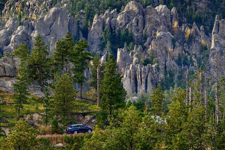
Wind Cave National Park
Beneath the rolling prairies and ponderosa pine forests of the Black Hills lies one of the world’s longest and most complex cave systems. Wind Cave contains over 167 miles of explored passages, making it the sixth-longest cave in the world, with new sections still being discovered.
What makes Wind Cave truly special is its rare boxwork formations, thin calcite fins that create honeycomb patterns on the walls and ceilings. It’s stunningly beautiful and found in such abundance nowhere else on Earth. Above ground, the park protects a mixed-grass prairie ecosystem where bison, elk, and prairie dogs roam.
I took the Natural Entrance Cave Tour, which involves climbing 300 stairs, most of them on the way out, and whilst my legs complained, it was absolutely worth it to see those remarkable boxwork formations up close.
Wind Cave National Park Key Facts:
Wind Cave was the 7th National Park, created back in 1903
The current explored length of the cave is 167 miles, making it the sixth longest cave in the world
Wind Cave contains the world’s largest concentration of boxwork rock formations
The cave maintains a constant temperature of 12°C (54°F) all year round
On the surface, the park is also home to bison, elk, pronghorn and prairie dogs
Getting to Wind Cave National Park:
Nearest airport is Rapid City (RAP) about 55 miles north of the park
The nearest towns are Hot Springs (11 miles south) and Custer (22 miles north)
Travel Tips for Wind Cave National Park
Cave tours, like the one that I did, must be booked in advance, especially in summer
There are several tour options available ranging from an easy one-hour walk to more strenuous four-hour expeditions. You should choose according to your fitness level, as there are a lot of steps
Wear layers; the cave maintains a cool temperature, regardless of outside conditions
Sturdy shoes with good grip are essential, the cave paths can be slippery
Above ground, the park is excellent for wildlife viewing, particularly along the Rankin Ridge area
The Wildlife Loop Road (shared with Custer State Park) offers some of the best bison viewing in America
Rangers are passionate and knowledgeable; their guided talks add real depth to the visitor experience
I would suggest allowing a full day to enjoy both the cave tour and surface attractions
Hot Springs, to the south of the park, is a charming town, with historic buildings and natural hot springs
Jewel Cave National Monument
Just a few miles west of Wind Cave lies its slightly younger sibling, Jewel Cave, the third-longest cave in the world with over 220 miles of mapped passages. Whilst Wind Cave is known for boxwork, Jewel Cave sparkles with calcite crystals that line the walls like sugary frost, giving the cave its name. I’ll confess that visiting both caves in the same trip felt slightly indulgent, but they’re genuinely different experiences, and if you enjoy underground exploration, both are well worth your time. The ranger-led tours here are excellent, combining geology, history, and just enough humour to keep everyone engaged.
Jewel Cave National Monument Key Facts:
Jewel Cave was designated a National Monument in 1908
The currently explored cave is over 220 miles long, making it the third-longest cave in the world
The calcite crystals in the rocks give the cave its sparkling appearance
The cave maintains a constant temperature of 9°C (49°F) all year round
Two local prospectors discovered the cave in 1900, drawn by wind rushing from the small opening in the rock
Getting to Jewel Cave National Monument:
Nearest airport: Rapid City (RAP) 50 miles northeast
Nearest town: Custer (13 miles west)
Travel Tips for Jewel Cave National Monument:
Much like Wind Cave National Park, tours must be booked in advance, and they sell out quickly in summer
The Scenic Tour (1½ hours, and moderately strenuous) is the most popular and showcases all the cave’s highlights
For the adventurous, the Wild Caving Tour (four hours) involves crawling through tight passages and getting properly dirty. It is not for me, but remarkably popular, so book well in advance
Dress warmly; the cave is chilly at 9°C (49°F) and humidity is high, you are likely to get dripped on more than once
There are more than 700 stairs on the Scenic Tour and no other way out!
Above ground, there are some lovely hiking trails through ponderosa pine forests
Photography is allowed in the caves, but flash photography is prohibited. For best results use a high ISO level, a wide aperture, and if you can carry one, a tripod
Combine your visit with Custer State Park and Mount Rushmore for a packed day in the Black Hills
The nearby town of Custer has good restaurants and accommodation options
Mount Rushmore National Memorial
Let’s address the elephant in the room, or rather, the four 60-foot-tall presidential heads carved into a granite cliff face. Mount Rushmore maybe touristy, with a gift shop the size of a small warehouse, but standing in front of George Washington, Thomas Jefferson, Theodore Roosevelt, and Abraham Lincoln’s carved faces is genuinely impressive. The scale is remarkable, the craftsmanship extraordinary, and the setting, high in the Black Hills with pine forests stretching in every direction, is undeniably beautiful. Sculptor Gutzon Borglum began work in 1927, and the monument was completed in 1941, just months after his death. It remains one of America’s most recognisable landmarks.
Mount Rushmore Key Facts:
Mount Rushmore was established in 1925 and designated a National Memorial in 1939
The four faces were carved between 1927 and 1941
The featured presidents are George Washington, Thomas Jefferson, Theodore Roosevelt, and Abraham Lincoln
Each head is about 60 feet (18 metres) high
The faces were sculpted by Gutzon Borglum, with his son, Lincoln Borglum, completing the work
Getting to Mount Rushmore National Memorial:
Nearest airport is Rapid City (RAP), 23 miles northeast
Nearest town: Keystone, 3 miles southwest
Travel Tips for Mount Rushmore National Memorial
Parking costs $10 (November 2025). This is not included in your National Parks Pass, but is valid for a full year, so keep your receipt
If you can visit early morning (before 9am) it is quieter, and you may catch the morning light on the faces
From May through to September, there is an evening light ceremony in which the faces are illuminated whilst rangers discuss each president
The Presidential Trail brings you closer to the base of the mountain with several viewpoints
Allow about two hours for a visit, longer if you want to explore all the trails and exhibits
The nearby town of Keystone is unashamedly touristy, but has some decent dining options
Combine this with a visit to Crazy Horse Memorial (about 17 miles away). This is an even more ambitious mountain carving, still in progress, honouring Lakota leader Crazy Horse
Consider visiting Custer State Park immediately afterwards for a dose of nature
The gift shop is admittedly enormous, but the ice cream is surprisingly good!
The Great American West
I look back fondly on my tour of the Great American West. What surprised me most was how much variety exists within these four amazing states; Wyoming, Idaho, and North and South Dakota. One day I was photographing bison in Theodore Roosevelt’s beloved Badlands, and the next I was descending into Wind Cave’s underground labyrinth. The landscapes shift from alpine to prairie to desert to forest, sometimes within an hour’s drive. It keeps you constantly engaged and slightly off-balance in the best possible way.
The region’s National Parks and Monuments tell America’s story in layers of rock, fossil, and human history. They preserve not just scenic landscapes, the importance of untouched wilderness, the value of scientific discovery, the need to remember difficult truths alongside celebrated victories. Whether you’re watching Old Faithful erupt for the tenth time, exploring a glittering cave system beneath the prairie, or standing in silence at Minidoka remembering injustice, these places ask you to pause, reflect, and appreciate.
If I could offer one piece of advice, it would be this… allow more time than you think you’ll need, for unexpected detours, wildlife encounters, and those perfect sunset that no itinerary can predict.
Richard has more than 25 years of experience working within the travel industry. He has travelled widely in Europe, the USA & Canada, Australia & New Zealand, South East Asia, as well as Southern Africa. He enjoys exploring National Parks and other wilderness areas.