In my ongoing quest to visit all America’s National Parks, a work trip to the Pacific Northwest provided the perfect opportunity to add to my list. Finding myself in Portland, Oregon, with a few days to explore I consulted a map and began planning a route.
Oregon may not have the PR machine of California, its noisy neighbour to the south, but in my opinion, it is all the better for it. Oregon is best known for its stunning natural landscapes, and although it may boast only one National Park for my list, it is fair to say that it offers a lot more to see and do beyond that.
It was whilst I was planning my Oregon travel that I discovered the ‘Seven Wonders of Oregon’. Not heard of them? Well, neither had I until my visit, so you are not alone. In truth the Seven Wonders are a creation of Travel Oregon, the state tourism board. However, I am here to tell you that you should take note, and definitely add them all to your list of ‘must visit’ locations in America. Oregon, you have been warned. We are on our way!
Summary:Join me as I explore the Seven Wonders of Oregon, from the towering peak of Mount Hood and the deep blue waters of Crater Lake National Park, to the striking rock formations at Smith Rock and the Painted Hills. Each wonder reveals a different side of this wild and beautiful state, where waterfalls, forests and coastline come together to create one unforgettable road trip through Oregon’s most iconic natural landscapes. |
Chapters:
| Oregon Travel Facts | |
|---|---|
| Size | 98, 379 square miles |
| Population | 4.2 million people |
| Largest City | Portland |
| Distance from the UK | 4,927 miles from London |
| Flight time from the UK | 9 hours 50 minutes (direct) |
| Time Zone | GMT – 8 Hours |
| Popular Airlines | British Airways (direct), American Airlines |
| Entry Requirements | UK visitors require a Visa or ESTA |
| Fun Fact | Nearly 50% of Oregon is forest |
| Visit Oregon |
Unless driving along the Pacific Coast, it is likely that you will arrive in Oregon via Portland, Oregon’s largest city. Direct flights from London to Portland with British Airways makes this journey as simple as it could possibly be. Although not one of the listed Seven Wonders, Portland is a quirky city, well worth exploring. I didn’t get to spend much time in the city, but I will come back to explore more. What I can tell you is that Portland’s reputation for food and drink is well warranted. It appears that there are craft breweries and coffee shops on every corner of the walkable city centre. And if you aren’t taken by the many street food trucks, then the high concentration of gourmet restaurants in the same area will ensure you don’t go hungry.

I began my Oregon holiday itinerary by heading west out of Portland, along the Columbia River to the shores of the Pacific Ocean.
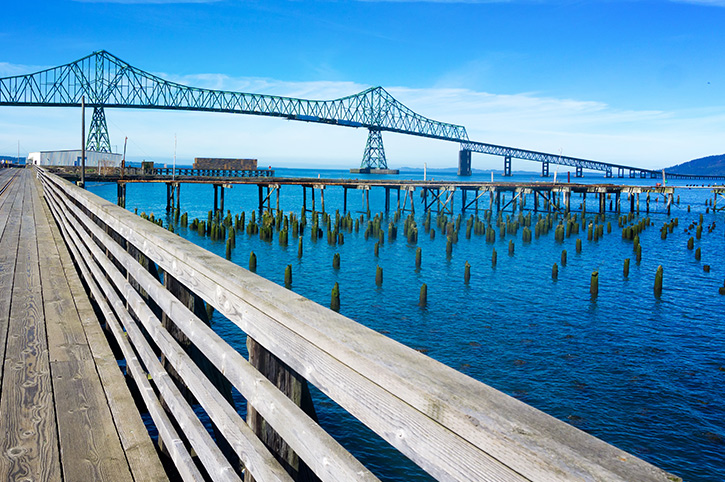
My first stop was the town of Astoria, which looks across the river to Washington State. Astoria is named as the oldest American settlement west of the Rocky Mountains and has a long history with the sea. A short stroll (or a ride on the narrated tourist-train) along the well-preserved Riverwalk will tell the story of Astoria from the fur traders of the early 1800s to the filming of the 1980s films, ‘The Goonies’ and ‘Short Circuit’. Needless to say, Astoria follows Portland’s lead with food and drink. Coffee and seafood are the specialities in Astoria and I would advise you to sample both.
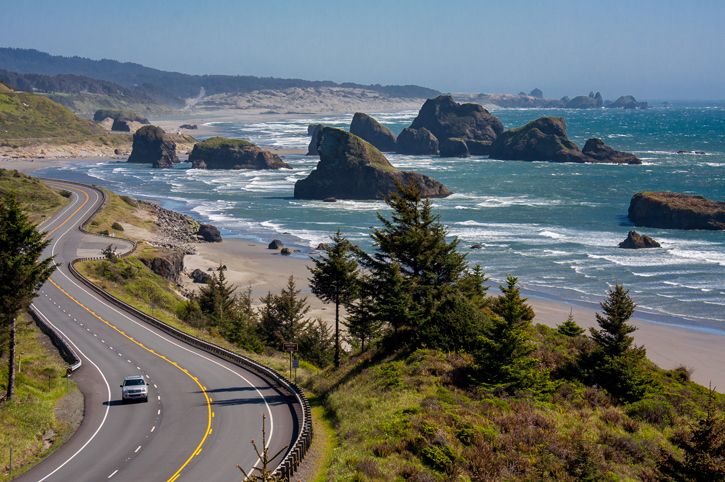
Oregon has 362 miles of rugged Pacific coastline, from Astoria in the north to Brookings in the south, so there is a lot to see, and you won’t do it all in a day. I planned three days to follow the coast road, Highway 101, but if Oregon teaches you one lesson it will be this; take your time. So, you may want longer. Many experts will insist that you have to drive the Pacific Coast from south to north, to keep the views on the correct side, however, I can confirm that in Oregon, that really doesn’t matter. All the roads are single-lane and traffic free, whilst the views are all around you. I stopped when I wanted to see more, and that was often.

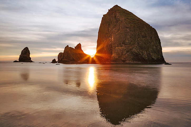
My first stop beyond Astoria was Cannon Beach, less than an hour’s drive. If ever there was a location that sums up the Oregon Coast, this is it. The beach is long, sandy, and scattered with driftwood. Then reaching out of the surf are multiple rock stacks, with the largest, Haystack Rock, reaching more than 70 metres above the waves. The Oregon Tourist Board know a good view when they see it, and Cannon Beach is on the front of all their brochures. When I was there it was a lovely day, so I walked along the beach, explored the tidal pools and spotted hermit crabs scuttling about the shore. It just felt the right thing to do when presented with a beach like this. If you can stay on Cannon Beach for sunset you will be rewarded with orange and pink colours reflected of the sea and the rocks, it is heaven for photographers (see top image).
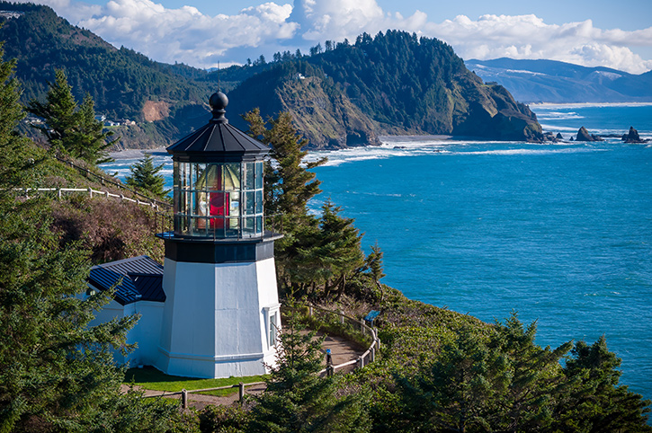
As well as fantastic beaches, lighthouses punctuate the coastline like exclamation marks. Yaquina Head, Heceta Head, and Cape Blanco are all worth a visit. My first lighthouse visit was at Cape Meares, a short detour from the town of Tillamook. The walk to the lighthouse is only a gentle incline and the coastal views from the top are spectacular. If you are lucky one of the rangers may also let you borrow their binoculars to spot grey whales commuting along the coast. Note to self: Always take your binoculars out of the car when you go for a walk!
Don’t think that you have to stick to Highway 101 all the way. In fact, some of the more remote beaches and the best views can be had from roads that branch off to hug the shoreline. Look out for Whiskey Creek Road that follows Netarts Bay to Cape Lookout, and Sandlake Road that takes you to Whalen Island. There are also numerous trailheads, that will take willing hikers to stunning views unreachable from behind the wheel. Take your time and go and explore.
There are always more seascapes to discover along the Oregon Coast. One of my favourites is the ‘Devil’s Punchbowl’ which close to Otter Rock. This collapsed sea cave has now surrendered to the Pacific swells, creating an hypnotic rise and fall of churning water. Further South, I also enjoyed the sea rhythms of ‘Thor’s Well’ near Yachats. At high tide the ocean appears to drain into this seemingly bottomless sinkhole. Just be sure to take care on the slippery rocks.

Charming seaside towns are scattered along the entire length of the coast, and larger towns like Newport, Florence and Coos Bay offer plenty of options for stopping overnight and independent restaurants. You can get some of the freshest fish and chips in these towns as well gourmet dinners. I also stopped in Yachats to visit the local farmers market and discovered some great handmade pizza, so those with an aversion to seafood won’t have a problem either.
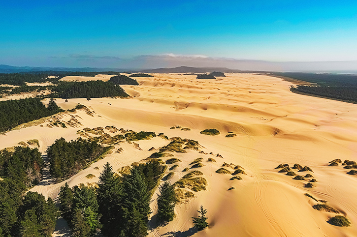
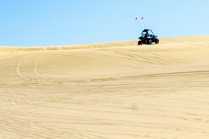
Between Florence and Coos Bay lies one of Oregon’s most unexpected landscapes: the Oregon Dunes National Recreation Area. These towering sand dunes, some reaching 150 metres above sea level, form the largest expanse of coastal sand dunes in North America. Stretching for forty miles along the coast, this remarkable recreation area encompasses thirty lakes, windswept sand hills, and pristine beaches. Walking amongst these sculpted mountains of sand feels utterly surreal, more Sahara than Pacific Northwest. I put on my hiking boots and disappeared for a couple of hours following the marked trails, but you can also explore on dune buggies or bikes, and there are plenty of opportunities to try your hand at sandboarding. From what I witnessed this appeared more like sand falling, so I confess I gave that one a swerve.
Every mile of Oregon’s Pacific Coast reveals something new, with each beach and viewpoint demanding a little more of my time. Once I reached the town of Brookings, a stone’s throw from the California border, I turned inland. I wanted to tick another National Park off my list, and visit number two on the list of the Seven Wonders of Oregon.
Nothing; not photographs, not guidebooks, not enthusiastic recommendations from fellow travellers, really prepared me for my first glimpse of Crater Lake. I’d driven up from my base in Klamath Falls, about an hour south, so my anticipation was growing long before I saw the ‘Welcome to Crater Lake National Park’ sign.
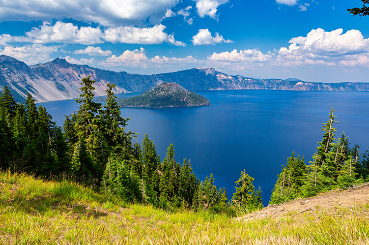
When I parked at Rim Village and walked those final steps to the edge, for my first glimpse inside the crater, I was rewarded by a view that seemed Photoshopped by nature itself. This wasn’t the blue of any other lakes that I’ve seen, it was something altogether otherworldly (my photos don’t really do it justice). The blue waters are almost too vivid. Contrasted with the green of the pine trees, and the browns of the crater sides, the blue of the deep water is mesmerising.
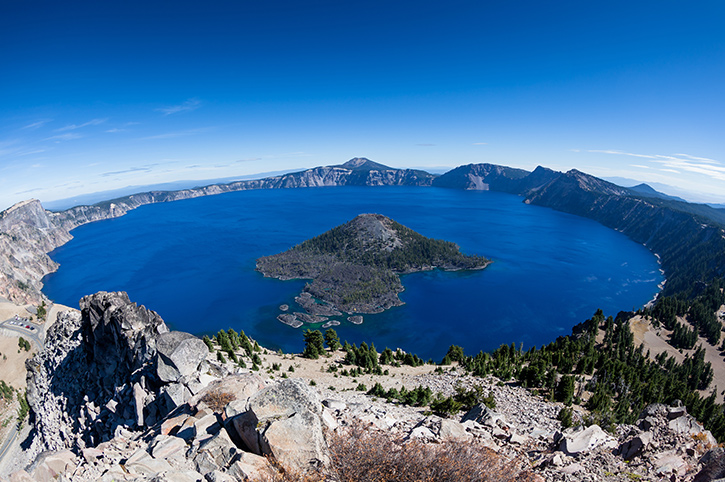
The ranger at Klamath Falls had told me that early autumn (I visited in September) offers a sweet spot at Crater Lake. The Rim Drive is fully accessible, the crowds of summer have dispersed, and weather is still cooperative, before winter’s heavy snows arrive. She was right. The 33-mile Rim Drive circuit became my day tour. I tried to stop at every designated viewpoint and several unofficial pull-offs that also demanded my attention. ‘Cloudcap Overlook’ on the east rim offered the highest vantage point, whilst ‘Watchman Overlook’ and ‘Discovery Point’ provided those postcard-perfect views. Each perspective revealed something new, the way cloud shadows shifted across the caldera walls, how you can see deep below the lake surface, and how Wizard Island emerges like a miniature volcano within the lake itself.
Once again, I pulled on my hiking boots and left the car to follow one of the trails. I can confess that the ‘Watchman Peak Trail’ tested me more than I’d anticipated. At 8000 feet elevation, every step had my lungs working overtime in the thin mountain air. The relatively short 1.6-mile round trip climbs 420 feet, zig-zagging up the volcanic slopes with increasing drama. But standing atop that historic fire lookout station, gasping and grinning, I understood why people call this hike essential. The panorama was breathtaking, the entire lake spread below like a gemstone with Mount Scott rising to the east, and on clear days (like mine), even distant Mount Shasta visible to the south. I had remembered my binoculars this time!
The ranger had suggested that I should also return to Crater Lake in winter for a different experience. From roughly November through to May, heavy snowfall blankets the National Park, including the Rim Drive. Winter transforms Crater Lake into a snow-draped wonderland with areas only accessible via cross-country skis or snowshoes. Whilst the south entrance remains open all year, snow depths can average 40 feet at the high altitude and sometimes remain well into the summer months. As I am not skilled at winter sports, I felt fortunate for my autumn timing.
I’d considered staying at Crater Lake Lodge, the historic stone and timber beauty perched on the caldera rim, but it closes later in the autumn, and my budget appreciated Klamath Falls’ more economic offerings. The hour-long drive each morning became part of my ritual, watching the landscape shift from high desert to mountain forest, with my anticipation building with every mile gained in elevation.
If you can bear an early start on holiday, then I do recommend arriving at Crater Lake for sunrise. It may be cold, but the low sunlight transforms that blue water into something even more magical. You will also have the viewpoints largely to yourself. Midday sun brings a harsher light for photography and peak visitor numbers. However, and most importantly, allow more time than you think you’ll need. Like all the rest of Oregon, Crater Lake isn’t a place to rush. It’s a place to sit, to breathe, and to comprehend the natural forces that created such beauty. It was also another National Park visited on my list, so I was a happy traveller.
Oregon holidays by Freedom Destinations


Portland | Astoria | Newport | Bandon | Crater Lake | Ochoco | Baker City | Joseph | Columbia River

Portland | Columbia River | Astoria | Klamath Falls | Crater Lake National Park

Seattle | Olympic National Park | Forks | Astoria | Crater Lake National Park | Columbia River Gorge | Mt. Rainier National Park
Portland | Astoria | Newport | Bandon | Crater Lake | Ochoco | Baker City | Joseph | Columbia River
Portland | Columbia River | Astoria | Klamath Falls | Crater Lake National Park
Seattle | Olympic National Park | Forks | Astoria | Crater Lake National Park | Columbia River Gorge | Mt. Rainier National Park
Whilst I have an ongoing love affair to America’s National Parks, I am also acutely aware that many of the State Parks throughout America are equally stunning, even though they may get less publicity. Oregon may have only one National Park, but it has plenty more natural wonders to offer. Leaving Crater Lake behind, my Oregon journey took me north towards Bend, a lively town that makes a great base for exploring the high desert landscapes of central Oregon. Just half an hour beyond Bend lies Smith Rock State Park, a completely different setting to the coastlines and volcanic lakes that I had already experienced. If Crater Lake is about water and stillness, then Smith Rock is about stone and activity.

Smith Rock is often described as the birthplace of American rock climbing, and you only need to spend a few minutes gazing up at the cliffs to understand why. Towering pinnacles of volcanic rock rise dramatically from the Crooked River Canyon, glowing shades of red and gold in the sunshine. Their vertical faces attract climbers from across the world, and when I visited, I could see tiny dots of colour clinging to the walls, ropes trailing like spider webs. I am not a climber myself, but it was fascinating to watch, and inspiring to realise that this relatively small state park is so well regarded in the climbing community.
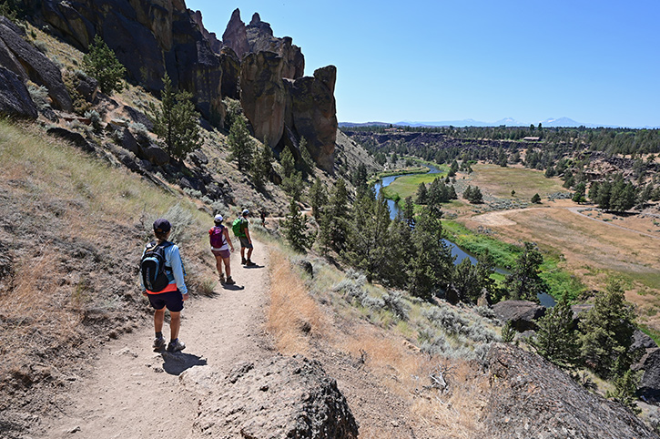
Even without ropes, there is more than enough to do. With limited time, I decided to hike the park’s most famous trail, ‘Misery Ridge’. The name alone might put you off, but I was told it rewards the effort, and that proved true. From the trailhead near the park entrance the path zig-zags steeply upwards, and in the midday heat I certainly felt the climb. The good news is that the trail is only a mile or so to the summit, and every pause for breath is accompanied by increasingly spectacular views. At the top, the panorama opens to reveal not only the spires of Smith Rock itself, but also, on a clear day, the distant snow-capped peaks of the Cascade Range.
The highlight for me was the view down onto “Monkey Face”, a 350-foot rock pillar that, from the right angle, does indeed resemble a primate’s profile. It is one of the most famous climbing routes in America, yet from the ridge you can appreciate its strange beauty without dangling from a rope. Watching the Crooked River winding gracefully through the canyon far below, it was easy to see why locals talk about Smith Rock with such affection.

If you prefer gentler walks, there are plenty of options along the riverbank, where the cliffs are reflected in the water and golden eagles often soar overhead. Wildlife is abundant here. In just a short stroll I saw a mule deer grazing in the sagebrush and heard the chatter of rock wrens echoing off the canyon walls. In autumn (during my visit) the cottonwoods along the river begin to turn yellow, adding another splash of colour.
Something to be aware of is that whilst parking at Smith Rock is plentiful, you do need to purchase a day-use permit. The facilities are good, with toilets and picnic areas, though you will want to carry plenty of water, as shade is scarce. If you are staying in Bend, you can easily combine a half-day at Smith Rock with exploring the town’s breweries or the nearby lava fields.
My time here was short, but Smith Rock left a strong impression. It showed me a different side of Oregon; a dry, rocky landscape full of natural rock sculptures. However, the beauty of Smith Rock State Park was only my introduction to natures artwork. There was a lot more to come.
As I continued my journey east into Oregon’s high desert the scenery shifted again, from jagged cliffs and pine-dotted canyons to rolling grasslands and sagebrush. About two hours from Bend lies one of the most extraordinary landscapes I’ve ever seen, and certainly one that deserves its title: the Painted Hills.
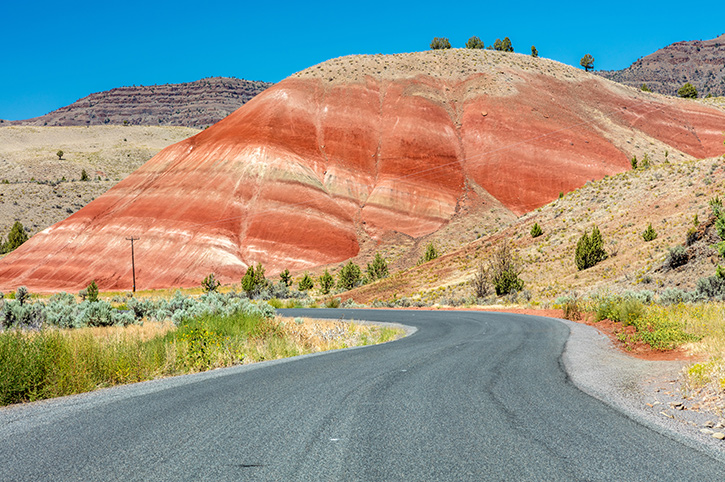
The Painted Hills are officially part of the ‘John Day Fossil Beds National Monument’, a protected area best known for its rich minerals and prehistoric fossils. But it is the hills themselves that draw most visitors. When I first arrived, I parked at the main overlook, and I swear that the view is literally breathtaking. Before me stretched a series of softly contoured hills, striped in deep reds, golds, and shades of black and green, like an artist had brushed watercolours across the landscape. The colours shift subtly with the light and season, so I am told that no two visits ever look the same. I was there in September, and the warm afternoon sun made the reds glow with a fiery intensity.

Walking the short trails that wind through the Painted Hills feels like stepping into another world. I chose the Painted Cove Trail, a simple boardwalk that loops through some of the most vividly coloured mounds. The soil here is so fine it almost looks like powder, and signs remind you to stick to the path to help protect this fragile landscape. It felt surreal to be so close to these natural works of art, and I found myself taking hundreds of photos, trying to capture the colours. The Painted Hills Overlook Trail offers a wider panorama, and although it’s only half a mile each way, it’s worth lingering to watch the colours shift as the sun moves across the sky.
As an eternal geography student, what fascinated me most was learning how these colours were formed. The bands represent different layers of volcanic ash and claystone, each deposited millions of years ago in varying climates. The yellows and golds are from ancient grasslands, the reds indicate wetter, more tropical periods, and the darker tones mark times when volcanic activity dominated the region. In a sense, the Painted Hills are a timeline of Earth’s history, laid out in layers that you can walk alongside.
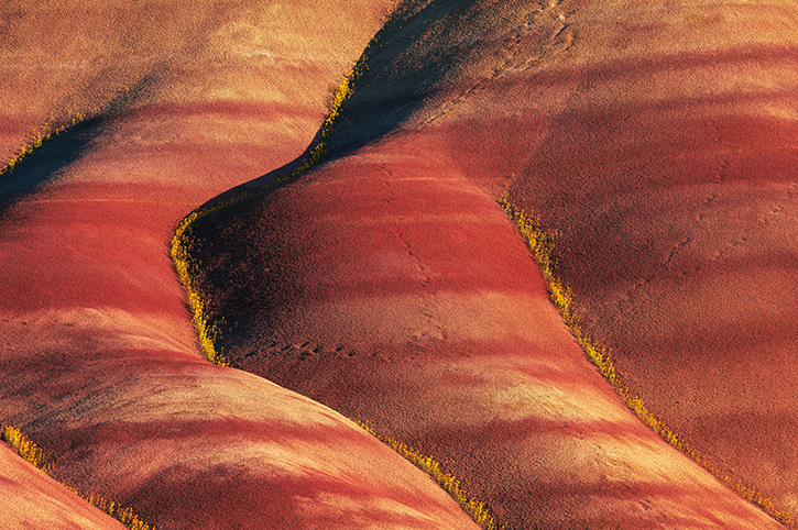
Photography here is irresistible, and I would suggest timing your visit for either early morning or late afternoon when the low light makes the colours richer and the shadows more dramatic. Even if you are not a keen photographer, the simple act of standing still and watching the hills glow is worth the trip alone.
There are no restaurants or shops within the Monument, so it’s best to bring water and snacks with you. The nearest small town is Mitchell, which makes a handy base for exploring, and Bend is the larger hub if you prefer more options. The Painted Hills are remote, but that is part of their charm. The relative quiet adds to the otherworldly atmosphere, and when I visited, I found myself with entire viewpoints to myself.
The Painted Hills may not be as vast as Yellowstone or as famous as Yosemite, but they are every bit as memorable.
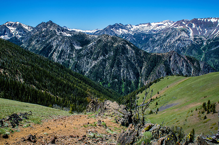
From the desert hues of the Painted Hills, my route carried me north-east into a corner of Oregon that feels both remote and spectacular. The journey itself was half the reward. Leaving the high desert behind, I drove through a patchwork of wheat fields and cattle ranches, with wide open skies and barely another car in sight. After La Grande, the road then began to climb gently as the landscape grew greener, before narrowing into the Wallowa Valley. At one point I crested a hill and the full sweep of the Wallowa Mountains came into view, jagged and snow-streaked even in late summer. It was one of those ‘pull over and stare’ moments.

Finally, the road curved along the edge of Wallowa Lake itself. Perfectly blue and impossibly still, the five-mile-long lake stretched out ahead of me, flanked on both sides by towering peaks. It felt as though I had driven into a postcard. By the time I reached Wallowa Lake State Park, at the southern tip, I already knew this was going to be a special stop. The park has that classic American State Park feel, with a wide campground shaded by pines, picnic areas overlooking the water, and a small marina where you can rent boats or kayaks. I didn’t camp on this occasion, but I could see why so many families choose to. The setting is peaceful, and the lake itself is inviting, whether you fancy an early morning paddle or simply want to dip your toes in the crystal-clear shallows.

The real draw, however, is the Wallowa Mountains themselves. From the park you can take the Wallowa Lake Tramway, an aerial gondola that whisks you from the lakeshore up to the summit of Mount Howard at over 8,000 feet. The ride is smooth and surprisingly serene, as you glide higher and higher above the forest, with the lake shrinking into a silver ribbon below. At the top, a network of short trails lead to viewpoints in every direction. To the north you can see deep into the Eagle Cap Wilderness, to the south the fertile Wallowa Valley stretches out like a patchwork quilt, and on a clear day the distant Seven Devils Mountains of Idaho are visible on the horizon.
I opted to follow the Summit Loop Trail, which is just over a mile long but gives you a taste of the alpine environment. Even in September, the air was crisp and the wildflowers were still clinging on. Golden-mantled ground squirrels darted across the path, and a pair of ravens circled on thermals above the ridges. It was a reminder that this part of Oregon feels wilder and less tamed than some of the other ‘Wonders’ that I had visited.
Back down at lake level, the town of Joseph is only a couple of miles away and well worth a stop. It has a thriving arts scene, with bronze foundries, galleries and sculptures lining the main street, plus a good selection of restaurants serving hearty meals to hungry hikers. I grabbed a table at a local café, where the friendly owner insisted that I try a huckleberry milkshake, apparently a regional speciality, and deliciously sweet after a long day outdoors.
Driving out of Joseph the following morning, I realised just how tucked away it is. The road follows the curve of the lake before opening into the Wallowa Valley, where cattle graze and red barns dot the farmland, all framed by the mountains receding in your rear-view mirror. It felt like leaving a hidden world behind, one that only reveals itself to those who make the journey.
Wallowa Lake State Park is quite a distance from Oregon’s bigger towns, so allow time in your itinerary to get here. The reward is a sense of seclusion that makes the scenery even more special. Remember to bring layers, as the mountain weather can change quickly, particularly if you take that tram ride to the summit.
Beginning my drive back towards Portland, I still had two of ‘Oregon’s Wonders’ to visit. However, even from the remotest part of Oregon that I was leaving, the next Wonder was soon visible ahead of me.
Mount Hood announces itself long before you reach it. At 11,250 feet, Oregon’s highest peak dominates the western skyline with an almost magnetic presence. As Highway 26 curved closer to the mountain, each mile amplified Mount Hood’s conical shape, and I found myself pulling over repeatedly at roadside viewpoints, unable to resist another photograph.
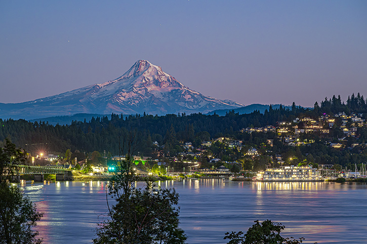
After days exploring remote northeastern Oregon, the journey westward brought me welcome civilisation again at Hood River, the charming town I’d chosen as my base for exploring Mount Hood. Hood River sits at the panoramic crossroads of the Columbia River Gorge and the Cascade Range, and I quickly understood its appeal beyond just proximity to the mountain.
The town itself captivated me with its blend of outdoor adventure culture and sophisticated small-town charm. I spent the evening at ‘pFriem Family Brewers’, where I could see the Columbia River whilst sampling some exceptional craft beers. The waterfront buzzed with energy with colourful kites soaring in the gorge winds. Hood River is famous for its craft breweries, with Full Sail Brewing and Double Mountain Brewery also being popular spots to sample local ales, so I made it my mission to visit them all during my brief stay.
Downtown Hood River charmed me with its historic buildings housing boutique shops, farm-to-table restaurants, and art galleries. The vintage Hood River Hotel became my comfortable home base, its character and central location perfect for evening strolls through town after long days on the mountain. From my room, I could see Mount Hood rising majestically to the south, a perfect snow-capped pyramid with an almost magnetic presence.
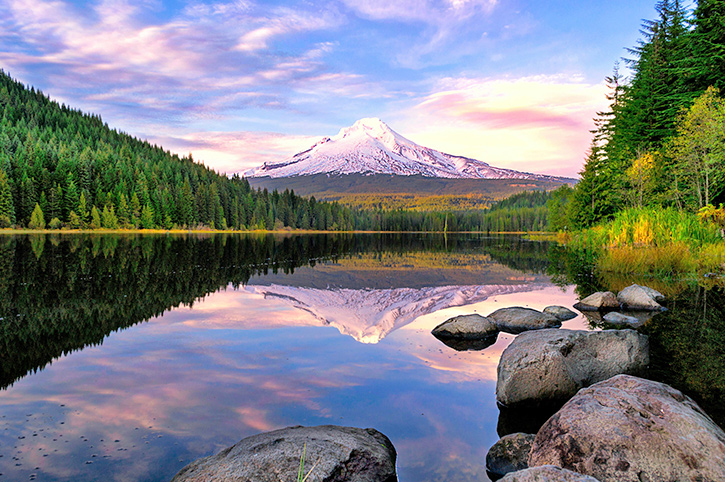
In the morning, I drove the scenic route south toward the mountain, watching Mount Hood grow larger and more imposing with every mile. The real revelation came at Trillium Lake, about six miles past Government Camp. I’d risen early specifically for this location, arriving with the early sun still painting Mount Hood’s glaciers a golden hue. The lake’s mirror-smooth surface created that iconic reflection shot every photographer dreams of, mountain and sky doubled, perfection meeting perfection. I wasn’t alone; a handful of dedicated souls clutched tripods and thermoses, united in reverent silence.
Perched at 6,000 feet, on Mount Hood’s south slope, Timberline Lodge became my base for the day. Constructed in 1937, this magnificent structure was built during the Great Depression. Walking through its massive timber-framed entrance, I felt transported to another era. The lodge was designed in a rustic style similar to National Park lodges, with asymmetrical design, native materials, and a roughness reminiscent of pioneer craftsmanship. Hand-carved newel posts, wrought-iron fixtures, and colourful handwoven textiles transform the interior into a living museum of 1930s craftsmanship. I lingered over lunch in the Cascade Dining Room, watching skiers and snowboarders carve turns on Palmer Glacier through floor-to-ceiling windows. Yes, summer skiing exists here year-round. The hearty mountain fare felt appropriate at altitude, warming me for the afternoon’s hiking adventure.
Film buffs will recognise Timberline Lodge’s distinctive exterior from Stanley Kubrick’s “The Shining,” though I must note the film’s interior scenes were shot elsewhere, and the management understandably keeps references minimal; nothing dampens alpine charm quite like horror film associations.

I’d chosen the Mirror Lake Loop, a moderately challenging route taking about two hours to complete. The well-graded trail climbed steadily through old-growth forest before opening onto the serene alpine lake. The Mirror Lake Trail offers picture-postcard views of Mount Hood. I’d positioned myself at the lake’s south end for the classic reflection shot, though afternoon breezes had ruffled the water’s perfect morning calm.
I’d considered attempting a section of the famous Timberline Trail, a 39.8-mile circumnavigation of Mount Hood with nearly 10,000 feet of elevation gain but wisely recognised my limitations. The trail’s fast-moving glacial river crossings are typically the most challenging aspect, and September’s early autumn conditions meant swollen streams from recent storms.
I don’t know if it was the mountain air, or the thought of frequenting another gastro-pub , but I was looking forward to returning to Hood River at the end of the day.
Leaving Hood River on my final morning, I made the deliberate choice to take the Historic Columbia River Highway westward towards Portland rather than the faster Interstate 84. This legendary scenic route, completed in 1922, was America’s first planned scenic roadway, and I wanted to experience it properly. As with the previous few days in Oregon, that meant slowly, with time to stop at every viewpoint and waterfall that beckoned.
The highway immediately delivered on its promise. Winding through dense forest with glimpses of the mighty Columbia River below, I felt transported to another era. The road’s gentle curves and stone guardrails spoke of careful craftsmanship from a time when the journey mattered as much as the destination.

Multnomah Falls arrived with fanfare, and with it, people. Even in early autumn, Oregon’s most famous waterfall drew substantial visitors. At 620 feet, it’s the tallest waterfall in the Columbia River Gorge, plunging in two magnificent tiers. I’d arrived mid-morning, which proved wise, as by noon the car park was full.
The iconic Benson Bridge, spanning the gap between the falls’ two tiers, became my hike goal. The paved trail climbs steeply for that quarter-mile, zig-zagging up alongside the thundering cascade. Standing on the bridge, spray soaking my jacket, the sheer power of the water was humbling. The upper falls roared above whilst the lower tier crashed into the pool below. I was suspended between two forces of nature, both awesome and slightly terrifying at the same time.
Just a mile or so along the Historic Columbia River Highway lies Wahkeena Falls, another of Oregon’s graceful cascades. Unlike Multnomah, which commands the spotlight with its sheer height, Wahkeena is more subtle, tumbling in a series of tiers down a rocky slope before gathering into a stream that flows beneath the highway. The name means “most beautiful” in the Yakama language, and while I’ll leave the ultimate ranking of Oregon’s waterfalls to others, I could see why it has earned such admiration. The coach parties at Multnomah Falls hadn’t followed me so I decided to get my boots on for one last hike.
There is a short path from the car park that takes you up to a stone bridge at the base of the falls. From here, you can feel the spray drifting across, cool and refreshing on a warm day, and you can admire how the water fans across the rocks, giving it a softer, more delicate appearance than Multnomah. Many visitors stop here, grab a photograph, and continue on their way, but I’d recommend stretching your legs a little further.
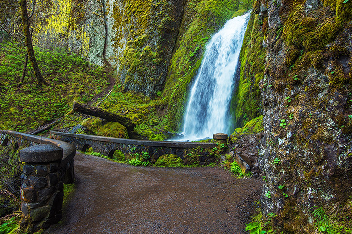
From the Wahkeena Falls Trailhead, a series of zig-zags lead you up through lush, shaded forest. The path is steep in places, but every pause offers glimpses back across the Columbia River Gorge, and the higher you climb the quieter it becomes. After about a mile, you reach Fairy Falls, one of the Gorge’s most enchanting sights.
Fairy Falls is a small cascade compared to its famous neighbour, but it has a charm that completely captivated me. The water spills in a perfect veil over a fan-shaped rock face, only about twenty feet high, but so symmetrical and graceful that it looks almost man-made. The surrounding moss-covered rocks and dense greenery give it a secretive, almost magical feel — as if you’ve stumbled across a hidden garden in the forest. Standing here, with the gentle roar of water and the cool shade of the trees, I understood why locals often rate Fairy Falls as one of their favourites, despite its modest size.
What I loved about this part of the Columbia River Gorge was the contrast. Multnomah is grand, busy, and iconic, while Wahkeena and Fairy Falls are quieter, more intimate, and encourage you to slow down. I had fully adopted the Oregon way of life by now.
Just minutes further west, Bridal Veil Falls offered another spectacle. A delicate two-tiered cascade that lives up to its name. The half-mile trail descended through old-growth forest to a viewing platform where the 118-foot falls tumbled gracefully over mossy cliffs. By this point it was difficult to pick a favourite.
My next stop came quickly. Latourell Falls, cascades 249 feet in a single dramatic plunge. The short quarter-mile trail led to the base where I stood mesmerised by the basalt column backdrop, those distinctive hexagonal rock formations reminiscent of Giant’s Causeway in Northern Ireland. The sun filtered through trees and spray, creating magical rainbows. The moss-covered bridge framing the falls made for a perfect photograph, and I appreciated having this lesser-known gem largely to myself.
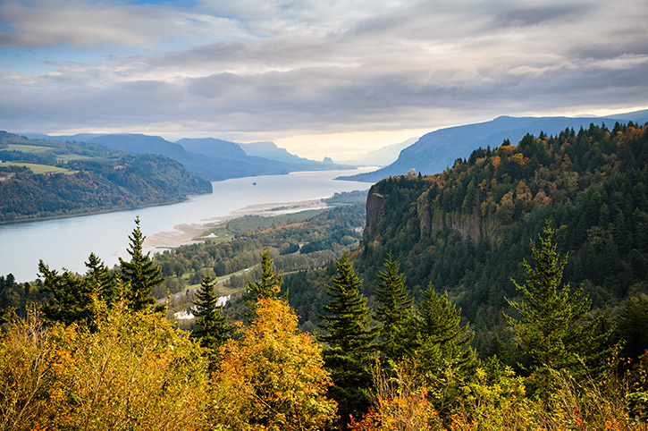
My final stop along the Columbia River Gorge was Crown Point Vista House. Perched 733 feet above the Columbia River on a dramatic promontory, it was built in 1918 as both a rest stop and observatory. Today this octagonal Art Nouveau masterpiece commands one of America’s most spectacular viewpoints. I climbed to the observation deck to take in the panoramic view that stretches for miles in both directions. The Columbia River snaking through the Gorge like liquid silver, waterfalls visible in the distance, wind turbines dotting Washington’s hills across the water.
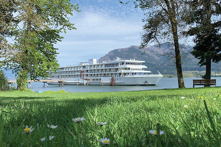
Interestingly from this viewpoint you could also see the river cruise boats making their way slowly along the Columbia River Gorge. A river cruise must give you a completely different view of the gorge, the waterfalls and the mountains beyond. Maybe less hiking, so perhaps something for me to explore the next time a visit Oregon.
From here it was only a short journey back to Portland. With my evening flight awaiting me at the airport, I dropped back down onto the main Interstate and followed the Columbia River back into Portland to complete my journey around Oregon’s Seven Wonders, and make my way back home.

In a few unforgettable days, Oregon proved that a State with only one National Park can still deliver a lifetime’s worth of epic landscapes. From sea stacks on the Pacific Coast to the sapphire stillness of Crater Lake, from Smith Rock’s sun-baked spires to the watercolour curves of the Painted Hills, from the alpine calm of Wallowa Lake to Mount Hood’s glacier glow and the waterfall symphony of the Columbia River Gorge, the Seven Wonders of Oregon felt less like a checklist and more like a perfectly paced Oregon road trip.
What tied it all together was the ease of travel and the state’s unshowy charm. Good coffee, better beer, friendly towns, and roads that invite you to linger rather than rush. If there’s one tip I’d pass on, it’s to build in time. Time to pull over for unexpected views, time to hike a mile further, time to watch the sunlight change. Come in shoulder season, away from peak summer, if you can, carry layers and water, and keep your binoculars handy!
I arrived chasing another National Park and left with a whole lot more. Oregon rewards curiosity, slow travel and those who like their adventures varied. The joy here is not only the destinations, but the journeys between them.
Richard has more than 25 years of experience working within the travel industry. He has travelled widely in Europe, the USA & Canada, Australia & New Zealand, South East Asia, as well as Southern Africa. He enjoys exploring National Parks and other wilderness areas.