As teenagers, my Australian friend and I set off in a car from Darwin, Northern Territory, to explore “The Outback”. We had a map and a full tank of gas, so we began our road-trip of discovery. Having driven beyond Humpty Doo, I had thought that we should be there, but Australian roads appear to be never-ending. Over the next couple of hours, we drove along tree-lined roads, and crossed the Adelaide and Mary Rivers, before we arrived in the town of Jabiru.
It was here, sitting on top of a rock at Nadab Lookout, watching the sun set beyond the red horizon, that we decided that we had made it. Despite having driven for less than three hours from a major city, we both agreed that we were looking at the Outback. It was like nothing I had ever seen before, and it was beautiful.
The Outback is the locally derived name for the vast, unpopulated areas that comprise Australia’s remote interior. Although it encompasses nearly three quarters of the Australian continent, The Outback supports less than 5% of the country’s population.
When you visit The Outback you can see a vast array of different landscapes and unique wildlife. It is an area of extremes that are often remote and apparently inhospitable, however, The Outback also includes places of exquisite beauty and is home to natural environments and wildlife found nowhere else on the planet. Just when you think that nothing could possibly survive in the vast open wilderness, an emu or a red kangaroo will hop by.

At the Top End, there is a tropical influence giving rise to wetlands and flood plains. As you travel through the Outback further south the colours change from green to red as trees are replaced by bush and then sands.
The Red Centre is epitomised by the unique rock formations of Uluru (Ayers Rock), Kata Tjuta (The Olgas) and Kings Canyon.
The southern extremity of The Outback is marked by the Flinders Range; a group of mountains more than 600 million years old. The rocky gorges and eroded peaks of the Flinders Range are about 5 hours’ drive from the city of Adelaide in South Australia.
The state of Northern Territory is almost entirely made up of The Outback, however for a state that is six times the size of the UK, there are large differences in environment from the north to the south of the state. The Top End encompasses the large peninsula at the northern extremity of the state that is dominated by tropical weather including monsoonal rainfall (over 1000 millimetres per year).
There are rivers, lakes and waterfalls that carve through the rocky landscape and the undergrowth can be dense and very green. This is not your stereotypical Outback environment, but it is a remote and unforgiving landscape that mirrors its drier siblings further south.

Kakadu is Australia’s largest National Park, covering around 20,000 square kilometres. It was here that my friend and I travelled all those year’s ago to begin our Outback adventure. We were rewarded with views of spectacular rainforests, rocky gorges and still lakes. It is also home to resident crocodiles so be careful where you choose to swim!

Situated within Nitmiluk National Park, Katherine Gorge is actually a combination of 13 separate gorges that carve their way through the local sandstone. The spectacular cliffs loom over the Katherine River that flows below. In the dry season the waters are mostly calm and ideal for swimming and canoeing, however, during the wet season the high and fast flowing waters restrict access.

Home to a variety of ecosystems, Litchfield National Park, marks the beginning of The Outback as you head south from Darwin. Dominated by water, the lush forests hide picturesque waterfalls and small lakes that are perfect for cooling off on a hot day. Florence Falls and Wangi Falls are perfect examples and are easily accessible from the main road.
There are few places in the world more remote than Australia’s Red Centre. Still within the boundaries of the Northern Territory, the desert plains and rocky escarpments give rise to some of Australia’s most recognisable Outback landscapes. The local rocks are high in iron content, which when they break up in this harsh environment, oxidise (or effectively rust) giving the landscape a distinctive red colour.

Alice Springs is the largest town in the Red Centre, with a population of just over 25,000. The town began back in 1872 as a telegraph station (connecting Darwin in the north with Adelaide in the south) but it is now a centre for tourist activity and the ideal place from which to explore the Outback. Helicopter flights over Ayers Rock or Balloon flights over the Outback are all possible from Alice Springs.

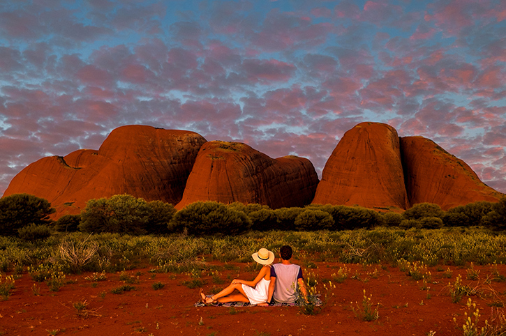
The Red Centre is a very sacred area for indigenous aboriginal people and the Anangu people have resided in the Uluru region for thousands of years. Their culture of art, storytelling and survival in the arid landscape are represented in Tjukurpa, the foundation of aboriginal life in the area. Any visit to the area is incomplete if you haven’t listened to their stories.

Although photos don’t do it justice, Uluru remains the most famous icon of the Australian Outback. This ancient sandstone monolith appears to change colour depending on the seasons and the time of day. Sunrise and sunset at Ayers Rock are particularly spectacular. Standing proudly 348 metres above the surrounding scrubland, Uluru dominates the surrounding area, and has been a spiritual centre for the local Anangu people that have lived in the area for more than 22,000 years. If you are staying close to Uluru then it is possible to tour around the rock with a local guide or even enjoy an outback dinner as the sun sets over the rock.
Just 30 kilometres from Uluru, and still within the Uluru and Kata Tjuta National Park, are the large sandstone domes of Kata Tjuta. In all there are 36 separate domes spread over an area of about 20 kilometres, the highest of which is Mount Olga. At one point in time, it is believed that all the rocks were joined together, and that the current rock formations have been weathered down over millions of years.
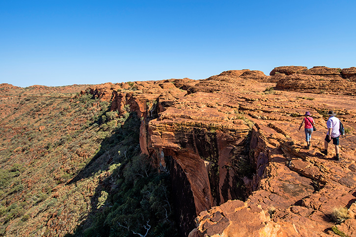
The towering red rock cliffs of Kings Canyon stand out from the rest of Watarrka National Park. The high sandstone walls reach up to 300 metres high, providing spectacular views across the surrounding sand dunes and desert. The cliffs act as shelter to provide a perfect ecosystem for palms and rare plants to thrive. To appreciate the views, it is best to explore on foot around the Kings Canyon Rim walk, that follows the canyon for six kilometres, through crevices and rock holes to eventually provide a panoramic view across surrounding area.

Stretching for 161 kilometres, west of Alice Springs, the West MacDonnell Ranges are less well known than their other Red Centre neighbours, but they are no less impressive and perfect for an Outback safari. The biggest difference is water. The Tjoritja West MacDonnell National Park has permanent water holes, not common to the Red Centre. Ellery Creek, Redbank Gorge and Ormiston Gorge all carry fresh cold water, perfect for a dip after a long bushwalk.
Australian Outback holidays by Freedom Destinations
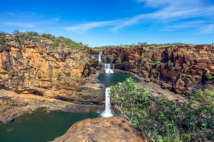
Australia’s north-western corner is home to the Kimberley region, one of Australia’s largest Outback frontiers. Covering an area three times the size of England, the Kimberley is home to just 40,000 people, however, there are plenty of unique rock features, deep canyons, meandering rivers and prolific wildlife to keep any visitor to this remote outback entertained for days. The nearest towns are Broome and Kunnunarra, but visitors to The Kimberley don’t tend to come looking for company.

The Purnululu National Park is remote; access to the park’s entrance is around 50 kilometres from the nearest paved road, and then a further 100 kilometres to the nearest settlement. In fact, its remoteness is why this area of the Outback remained relatively undiscovered until the 1980s. It is also why, even though the area is great to explore with a four-wheel drive vehicle, it is also popular to enjoy a scenic flight and view the unique rock formations from above.
Purnululu National Park is home to more than 100 different bird species as well as rare wallabies and other marsupials. However, it is the unique rock formations that attract most visitors. The Bungle Bungles are famous for their distinctive colours. Not as deep a red as their Northern Territory counterparts, the Bungle Bungles feature orange and black rings, formed over time by a mixture of sandstone, shale, and algae. Around 350 million years ago, the rocks were compressed together, creating these remarkable dome features that stand imperious above the grass covered plains that surround them.

For a truly unique Australian Outback adventure, explore The untamed Kimberley by following the Gibb River Road. This unpaved route is not for the feint hearted or inexperienced driver, but its natural rewards are plentiful on this exciting trip. With a duration of about two weeks, the road traverses some of the Kimberley’s most untouched Outback, on a road that was originally constructed to link vast cattle stations that dwarf the size of small countries. This 660 kilometre trail takes in Windjana Gorge, Tunnel Creek, Drysdale River Station and El Questro Wilderness Park.
The perfect example of what to expect along the Gibb River Road is Emma Gorge, one of the Kimberley’s most spectacular and yet accessible gorges. Set in the El Questro Wilderness Park, around 100 kilometres from Kunnunurra, Emma Gorge sits between towering sandstone cliffs that form part of the Cockburn Range. A not too challenging bushwalk through the gorge will be rewarded by a picturesque freshwater waterfall that plunges into a deep blue pool.
Around five hours’ drive from Adelaide are the region’s largest mountain range; The Flinders Range. These mammoth mountains stretch for more than 430 kilometres across the South Australian Outback and provide some of the most dramatic and aesthetic outback scenery in Australia. It is a place rich in wildlife and of cultural importance to the local aboriginal people.

The lowest point on the Australian mainland is occupied by Lake Eyre, 15 metres below sea-level. This massive saltwater area is more than 140 kilometres long and nearly 80 kilometres wide, making it the largest in Australia. However, for the majority of the time the lake is actually dry, exposing a large salt expanse, covering an area larger than each of Australia’s cities. It is one of the least habitable areas in Australia’s vast Outback. However, the area is also beautiful; when dry the salt crystals create small oases of colour amongst the white salt, and when wet, the waters reflect a pink hue best viewed from above on a scenic flight. Don’t wait for the water though, the lake generally only fills once every decade!
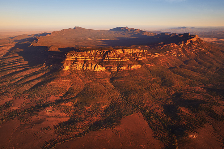
Around eight times the size of Uluru, Wilpena Pound is the crowning jewel of the Flinders Range. Appearing like an extinct volcanic crater, this natural amphitheatre has actually been created by two parallel mountain ranges connected by a bluff. From the ground it appears like a single mountain range towering over the landscape, but from a scenic flight over the Flinders Ranges it is possible to see the rocky rim protecting the bush covered plain inside. The area’s remoteness means that it is a perfect breeding ground for emus and kangaroos that can access the centre via Wilpena Gap, a gorge in the eastern range that has been cut by a creek draining the sunken land in the middle.
Exploring wilderness areas has always been a passion of mine and I always like to visit remote places when I travel. As you have already read, I have been fortunate enough to visit The Australian Outback and see some of the iconic sights first hand. Even now, it is difficult for me to comprehend the scale and vast emptiness of the Outback. It is exactly that scale of wilderness that draws me back time and again, as i know that I will never see the same view twice. Travelling to the Outback is easy. There are wilderness areas relatively close to every major city in Australia. Of course the Northern Territory lays claim to more of Australia’s Outback icons than most so travelling back here will always be a goal of mine.
Travelling through the Outback is not a journey that should be undertaken lightly. Distances are large, temperatures sometimes very high and resources such as food and water (and petrol) are scarce. Planning your journey is important to ensure that you enjoy the Outback safely. That is why you should always talk through your plans with an expert. All of the Freedom Australia team have travelled throughout Australia and are best placed to help you plan your Australian Outback holiday.
Richard has more than 25 years of experience working within the travel industry. He has travelled widely in Europe, the USA & Canada, Australia & New Zealand, South East Asia, as well as Southern Africa. He enjoys exploring National Parks and other wilderness areas.